 Click on the map for a larger view.
Opens in new window.
|
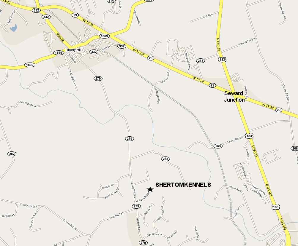
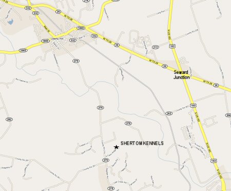
OVERVIEW OF LIBERTY HILL AND SEWARD JUNCTION
For individuals traveling from north of Hwy 183 from Killeen, Georgetown or Burnet areas.
DIRECTIONS FROM IH 35 IN GEORGETOWN
- From IH 35 go WEST on TX-29/W UNIVERSITY AVE toward I-35 S. Continue to follow TX-29 - 13.6 mi
- Turn SLIGHT LEFT onto FM 1869 - 0.7 mi
- Turn LEFT onto TX-332 LOOP/Main St./CR 279 - 0.1 mi
- Turn SLIGHT RIGHT onto CR-279 - 2.9 mi
- Turn LEFT onto N FAWN RIDGE DR - 0.3 mi
- End at 301 N Fawn Rdg Leander, TX 78641-8457
Estimated Time: 26 minutes Estimated Distance: 17.63 miles
DIRECTIONS FROM BURNET
- Start out going EAST on TX HWY. 29 from US 281. Continue to follow TX HWY. 29 - 19.6 mi
- Turn RIGHT onto TX-332 LOOP at the signal light when you get into Liberty Hill. See Shell station on your left at
this intersection - 0.5 mi
- Come to 4 way stop sign in downtown Liberty Hill. Stay straight through downtown - 0.1 mi
- Turn SLIGHT RIGHT or STAY STRAIGHT onto CR-279 - 2.9 mi
- Turn LEFT onto N FAWN RIDGE DR - 0.3 mi
- End at 301 N Fawn Rdg Leander, TX 78641-8457
Estimated Time: 33 minutes Estimated Distance: 23.78 miles
|
 Click on the map for a larger view.
Opens in new window.
|
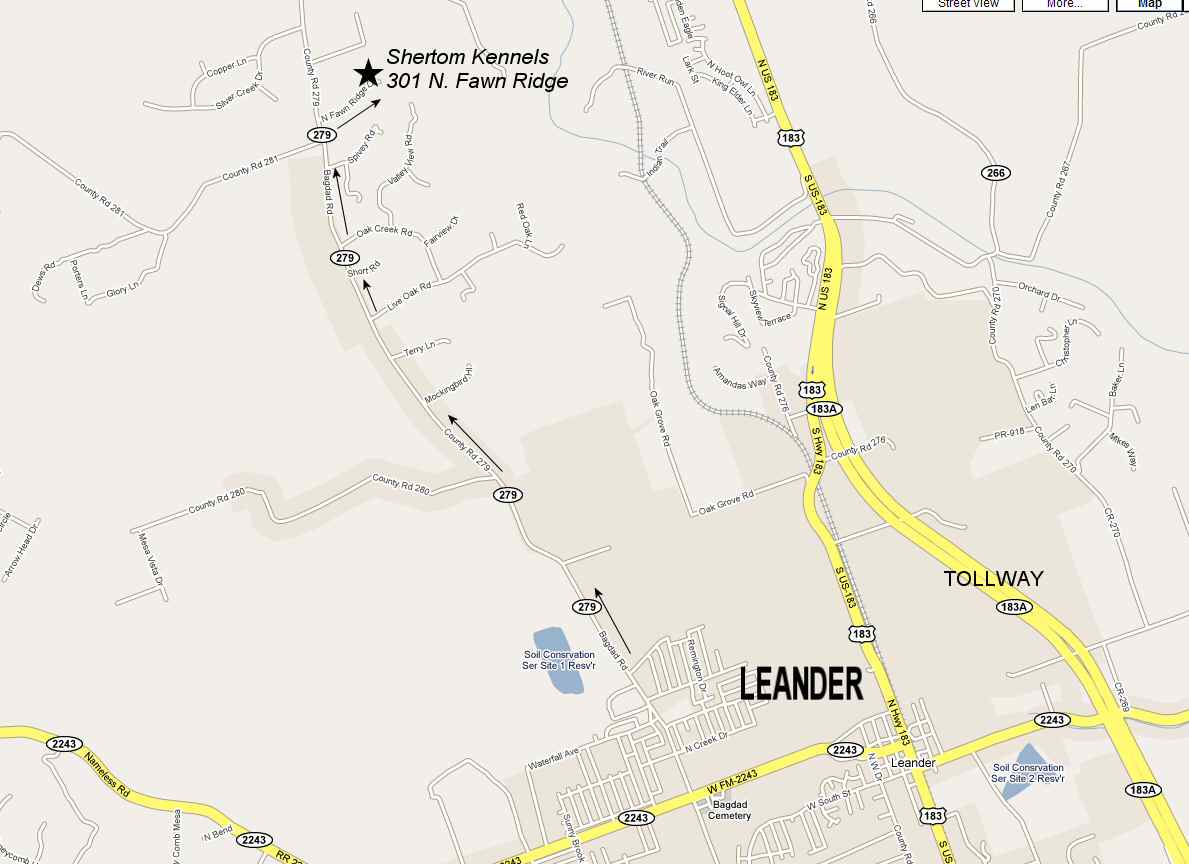
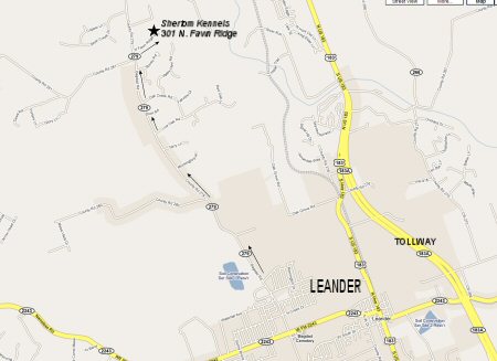
OVERVIEW OF LEANDER AREA
This is an overview of the Leander area showing where Shertom Kennels is located in relation to the city of Leander, Hwy
183 and Tollway 183A.
|
 Click on the map for a larger view.
Opens in new window.
|
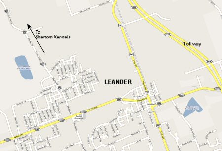
DETAIL OF LEANDER
This is a detailed map of the city of Leander showing Hwy 183, Tollway 183A and 2243 and 279 leading to Shertom
Kennels.
DIRECTIONS FROM HWY 183 IN CENTRAL LEANDER
Option #1
- Stay on Hwy. 183 heading north from Leander and turn left onto Old 2243 West where you will see an HEB Plus on your
left.
- Go one mile and at the signal light, turn right onto Bagdad Road aka County Road 279
- Then go approximately 3.8 miles and turn right onto N. Fawn Ridge Dr. where you will see our large Shertom Boarding
Kennel sign there on the right corner.
- Go 1/3 mile and turn left into our gate at 301 N. Fawn Ridge Dr. where you will see more kennel signs on the fence.
- Pull into the gate and park in front of the first building on the left that says Office.
Option #2
- Head north on Highway 183 from Leander and see an HEB Plus on the left corner of 183 and Old 2243 West.
- Continue heading north on Hwy. 183 going past the HEB Plus and then turn left at the blinking yellow signal light
onto San Gabriel Parkway.
- Continue on San Gabriel Parkway until you get to a 4-way stop sign and then turn left onto Halsey.
- Follow Halsey around until it deadends and turn right.
- This is Bagdad Road also called County Road 279.
- Go about 3 miles.
- Turn RIGHT onto N FAWN RIDGE DR where you will see our large Shertom Boarding Kennel sign there on the right
corner.
- Go 1/3 mile and turn left into our gate at 301 N Fawn Ridge where you will see more kennel signs hanging on the
fence. Go to the first building on the left and park in front.
Estimated Time: 14 minutes Estimated Distance: 5.5 miles
For those coming from Bagdad Rd. south of FM 2243 in Leander
- Come up Bagdad Road heading north and come to FM 2243 with the cemetary on your right and cross over 2243 still
staying on Bagdad Road.
- Continue 3.8 more miles to N. Fawn Ridge Dr. and turn right where you will see our large Shertom Boarding Kennel
sign there on the right corner.
- Go 1/3 mile to 301 N. Fawn Ridge Dr. and turn left into our gate. Turn into the driveway and park in front of the
first building on your left that says Office.
|
 Click on the map for a larger view.
Opens in new window.
|
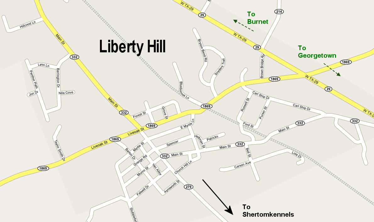
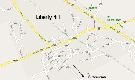
DETAIL OF LIBERTY HILL
This is a detailed map of Liberty Hill and showing routes to Shertom Kennels, Burnet and Georgetown.
|
 Click on the map for a larger view.
Opens in new window.
|
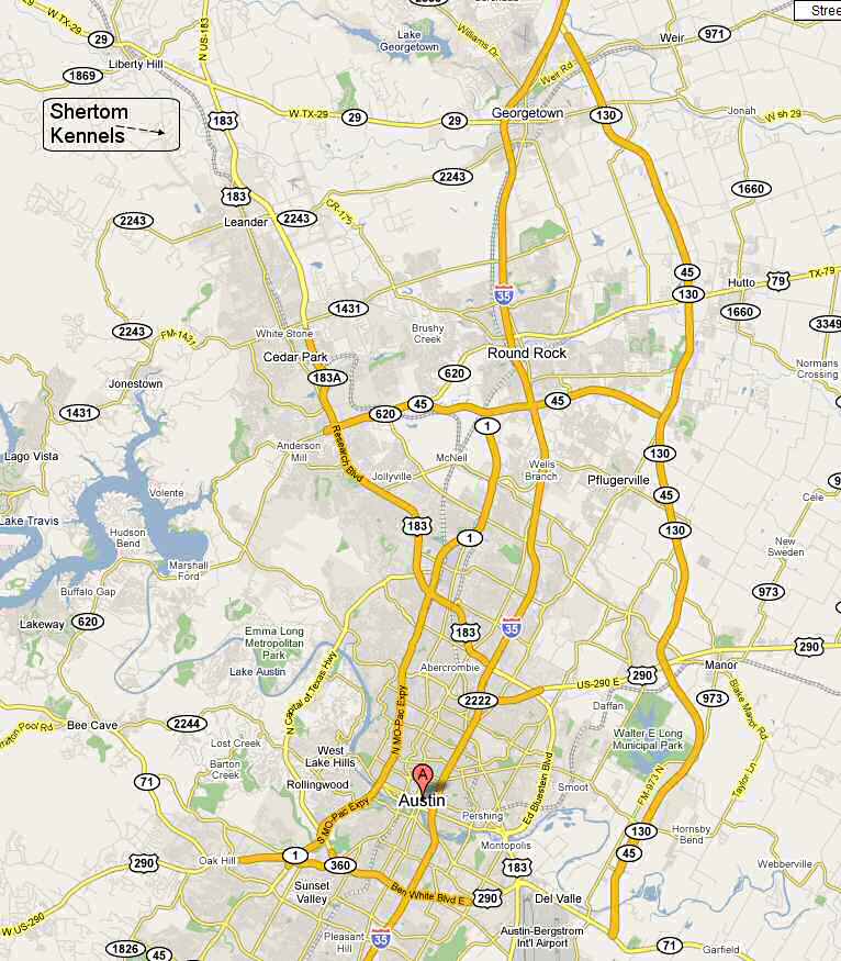
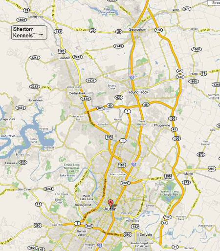
OVERVIEW OF AUSTIN AND SURROUNDING AREAS
This map shows Austin, routes leading into Austin, and where Leander, Liberty Hill, Georgetown, Cedar Park and Round Rock
are in relation to the metro Austin area.
DIRECTIONS FROM HWY. 183 & 620 NEAR LAKELINE MALL USING THE 183A TOLL ROAD
- Turn SLIGHT LEFT onto TX-183A N. -- 3.6 mi
- Turn LEFT onto FM 2243. -- 1.1 mi
- Turn RIGHT onto N HIGHWAY 183/ N US 183/ US-183/ S US-183/ FM 2243.
- Stay on Hwy. 183 heading north and cross over FM 2243 where you see the HEB Plus on your left. You will not turn
there.
- Instead continue heading north on Hwy. 183 going past the HEB and then turn left at the next possible left onto San
Gabriel Parkway where there is a signal light.
- After turning left, continue until you get to the stop sign and turn left onto Halsey.
- Follow Halsey around until it deadends and turn right.
- This is Bagdad Road also called County Road 279.
- Go about 3 miles.
- Turn RIGHT onto N FAWN RIDGE DR. -- 0.3 mi
- End at 301 N Fawn Rdg Leander, TX 78641-8457
Estimated Time: 26 minutes Estimated Distance: 14.86 miles
DIRECTIONS FROM HWY. 183 & 620 NEAR LAKELINE MALL NOT USING THE TOLL ROAD
- Head NORTH on HWY US-183. Continue to follow US-183. You will have to get off the freeway to avoid the Toll Road.
Watch the signs. Then you will be making a sharp left turn under the bridge to avoid going back on the toll road to
stay on regular 183. Watch the signs. Then you will be turning a sharp right which will now keep you on regular 183. -
7.2 mi
- Stay on Hwy. 183 heading north and cross over FM 2243 where you see the HEB Plus on your left. You will not turn
there.
- Instead continue heading north on Hwy. 183 going past the HEB and then turn left at the next possible left onto San
Gabriel Parkway where there is a signal light.
- After turning left, continue until you get to the stop sign and turn left onto Halsey.
- Follow Halsey around until it deadends and turn right.
- This is Bagdad Road also called County Road 279.
- Go about 3 miles.
- Turn RIGHT onto N FAWN RIDGE DR. - 0.3 mi
- End at 301 N Fawn Rdg Leander, TX 78641-8457
Estimated Time: 28 minutes Estimated Distance: 13.89 miles
DIRECTIONS FROM LAKELINE MALL DRIVE NOT USING THE TOLL ROAD
- Start out going SOUTHWEST on LAKELINE MALL DR.
- Turn RIGHT - 1.0 mi
- Turn LEFT - 0.2 mi
- Turn RIGHT onto S BELL BLVD/ US-183. Continue to follow US-183 - 7.2 mi
- Stay on Hwy. 183 heading north and cross over FM 2243 where you see the HEB Plus on your left. You will not turn
there.
- Instead continue heading north on Hwy. 183 going past the HEB and then turn left at the next possible left onto San
Gabriel Parkway where there is a signal light.
- After turning left, continue until you get to the stop sign and turn left onto Halsey.
- Follow Halsey around until it deadends and turn right.
- This is Bagdad Road also called County Road 279.
- Go about 3 miles.
- Turn RIGHT onto N FAWN RIDGE DR - .3 mi
- End at 301 N Fawn Rdg Leander, TX 78641-8457
Estimated Time: 28 minutes Estimated Distance: 13.89 miles
DIRECTIONS FROM PARMER LANE AND 620
-
- Start out going NORTH on PARMER LANE FROM THE 620 & PARMER LANE intersection. Come to FM 1431 and cross over 1431
heading north still on PARMER LANE which is now called RONALD W REAGAN BLVD/COUNTY ROAD 272. Continue to follow RONALD
W REAGAN BLVD for about 4 miles - 4.0 mi
- Turn LEFT onto FM 2243/ RR-2243 AT SIGNAL LIGHT. Continue to follow FM 2243 - 2.8 mi
- Turn RIGHT onto N HIGHWAY 183.
- Stay on Hwy. 183 heading north and cross over FM 2243 where you see the HEB Plus on your left. You will not turn
there.
- Instead continue heading north on Hwy. 183 going past the HEB and then turn left at the next possible left onto San
Gabriel Parkway where there is a signal light.
- After turning left, continue until you get to the stop sign and turn left onto Halsey.
- Follow Halsey around until it deadends and turn right.
- This is Bagdad Road also called County Road 279.
- Go about 3 miles.
- Turn RIGHT onto N FAWN RIDGE DR - 0.3 mi
- End at 301 N Fawn Rdg Leander, TX 78641-8457
Estimated Time: 21 minutes Estimated Distance: 15.84 miles
|